Data Access
Science RoCS instruments collect ocean and atmospheric observations autonomously aboard commercial ships as they sail their regular routes. Data from each platform are available through the links below.
Jump to: M/V Dawn · M/V Marjorie C · M/V Tysla · M/V Bulk Xaymaca · Argo Floats
M/V Dawn (2026–present)
About the platform
The M/V Dawn (IMO 9756298, MMSI 319238200) is a humanitarian vessel, refurbished in 2022, that sails under the flag of the Cayman Islands. The Dawn spends hurricane season in the Caribbean, transiting between countries and on call to assist with regional disasters.
Data collected and sensors
The Dawn carries a meteorological package and a FerryBox (-4H Jena) that continuously samples surface seawater.
- Weather (wind, air temperature, humidity, pressure, precipitation): two Vaisala WXT-536 weather stations
- Photosynthetically active radiation (PAR): Biospherical QSR-2150
- Incoming solar (shortwave) radiation: Kipp & Zonen SMP12 pyranometer
- Incoming longwave radiation: Kipp & Zonen SGR4 pyrgeometer
- Sea surface temperature: Sea-Bird SBE 38 (Intake)
- Surface temperature, conductivity, and salinity: Sea-Bird SBE 45 thermosalinograph (FerryBox)
- Dissolved oxygen: Aanderaa Oxygen Optode 4835 (FerryBox)
- Chlorophyll fluorescence and turbidity: WET Labs ECO FLNTU(RT) (FerryBox)
- Dissolved methane: Hydro-C CH4 FT (FerryBox)
- Dissolved carbon dioxide: Hydro-C CO2 FT (FerryBox)
Data access
Data from the Dawn are archived at the Woods Hole Open Access Server (WHOAS), where citation information is provided with each dataset.
Data from the Dawn are also shared with regional partners, including the University of the West Indies and the Caribbean Disaster Emergency Management Agency (CDEMA).
Data partners
Florida State University Center for Ocean-Atmospheric Prediction Studies (COAPS), Shipboard Automated Meteorological and Oceanographic Systems (SAMOS): SAMOS receives daily meteorological data and sea surface temperature and conductivity data from the M/V Dawn, quality-controls all data, and creates a science-quality product that is available on the SAMOS THREDDS server.
M/V Marjorie C (2026–present)
About the platform
The M/V Marjorie C is a cargo ship operated by Pasha Hawaii on a roughly two-week round trip between San Diego and Honolulu. Since July 1, 2026, it has carried the autonomous observing platform of the BEACONS project (Boundary Layer Exploration of Aerosols and Clouds ON Ships), led by Pacific Northwest National Laboratory, which measures aerosol and cloud properties along with atmospheric and surface weather conditions. The current campaign runs through September 2028.
Data collected and sensors
Instruments are operated by Pacific Northwest National Laboratory (PNNL), the University of North Dakota (UND), and the University of Washington Cooperative Institute for Climate, Ocean, and Ecosystem Studies (CICOES).
Meteorological and cloud instruments
- Surface weather: all-in-one weather sensor (Vaisala WXT536)
- Wind profiles: long-range scanning Doppler lidar (Halo Streamline XR+) with automated lens cleaning
- Cloud base height: Vaisala CL31 ceilometer
- Solar radiation: SPN1 Sunshine Pyranometer and HSR1 pyranometer
- Sky and cloud imagery: EKO ASI-16 All Sky Imager
- Present weather: Vaisala PWD22 Present Weather Detector
- Temperature and humidity profiles: microwave radiometer (MP-3000A) with automated calibration
Aerosol instruments
- Particle number concentration: water-based condensation particle counter (Aerosol Devices MAGIC250)
- Particle size distribution: differential mobility analyzer with water-based condensation particle counter, Handix Portable Optical Particle Spectrometer (POPS), TSI Aerodynamic Particle Sizer (APS), and Brechtel miniaturized Scanning Electrical Mobility Sizer (mSEMS)
- Particle volatility: Brechtel thermodenuder with mobility size spectrometer
- Light scattering: Acoem Aurora 3000 nephelometer
- Light absorption: Brechtel Tricolor Absorption Photometer (TAP)
- Carbon monoxide: Vaisala AQT560
Supplementary instruments
- Ship motion and timing: inertial measurement unit (VectorNav VN-300) and GPS-based precision clock
- Infrared imagery: marinized infrared cameras (AXIS Q35)
Instruments that may be added in Phase 2 of the project include Heitronics CT 15.85 infrared radiometers, a Micro Rain Radar (MRR-Pro), an AlphaSense OPC-N3 optical particle counter, a fog monitor on a gondola platform, and a DMT Cloud Condensation Nuclei Counter.
Data access
The BEACONS data portal shows the ship’s current position and the latest infrared camera image, and offers data from each trip at three levels: raw instrument output (00), standardized products with harmonized formatting and navigation (a1), and combined daily products (c0). Files can be filtered by instrument and data level before downloading.
Questions about BEACONS data can be sent to the project team at beacons@pnnl.gov.
M/V Tysla (2023–present)
About the platform
The M/V Tysla (IMO 9515400) is a vehicle carrier operated by Wallenius Wilhelmsen. In 2023, Julian Herndon of NOAA’s Pacific Marine Environmental Laboratory (PMEL) and the University of Washington’s Cooperative Institute for Climate, Ocean, and Ecosystem Studies (CICOES), working with Science RoCS and Wallenius Wilhelmsen’s engineers and port staff, installed an underway pCO2 system on the ship. It was the first NOAA pCO2 system installed with Science RoCS support. PMEL now uses the Tysla as a flagship platform for its long-running measurements of surface ocean carbon dioxide in the equatorial Pacific.
Data collected and sensors
- Carbon dioxide in surface seawater and air (fCO2/pCO2): NOAA-PMEL underway pCO2 system with a showerhead equilibrator and CO2 gas analyzer
- Sea surface temperature and salinity: measured alongside the pCO2 system
- Barometric pressure: barometric pressure sensor
Data access
Data from the Tysla are archived at NOAA’s National Centers for Environmental Information (NCEI) and contribute to the Surface Ocean CO2 Atlas (SOCAT).
- 2023 cruises: Pacific Ocean, Atlantic Ocean, Caribbean Sea (NCEI Accession 0315137)
- 2025 cruises: Indian Ocean, Pacific Ocean, Atlantic Ocean, Caribbean Sea (NCEI Accession 0315161)
- PMEL CO2 Data Discovery
- NOAA Surface Water pCO2 Measurements from Ships, FY2023 Annual Report, which describes the installation
M/V Bulk Xaymaca (2022–2026)
About the platform
The M/V Bulk Xaymaca, a 225-meter dry bulk carrier operated by Pangaea Logistics Solutions, became the first vessel equipped through Science RoCS in 2022. On its regular 17-day round trip between Jamaica and New Orleans, it crossed the western Caribbean, the Yucatan Strait, and the Gulf of Mexico Loop Current and its eddies. A hull-mounted acoustic Doppler current profiler (ADCP) measured currents at depth, and a Vaisala WXT-536 weather station recorded weather conditions. The ship was later sold, and its science equipment was decommissioned in January 2026.
Data collected and sensors
- Weather (barometric pressure, rain, true and relative wind speed, true and relative wind direction, humidity): Vaisala WXT-536 weather station
- Ocean currents: hull-mounted Teledyne RDI 75 kHz Ocean Surveyor acoustic Doppler current profiler (ADCP), with data collected using UHDAS (DOI: 10.5281/zenodo.8371260)
- Ship speed, heading, latitude, and longitude: GPS
- Heading, pitch, roll, and heave: Hydrins inertial navigation system
Data access
Data from the Bulk Xaymaca are archived at the Woods Hole Open Access Server (WHOAS), where citation information is provided with each dataset.
Argo Floats
The Argo Program, launched in 1999, is a global array of more than 3,900 robotic profiling floats that measure temperature and salinity in the upper 2,000 meters of the ocean and send their data to scientists and forecasters in real time. WHOI is one of Argo’s original member institutions and maintains about 10% of the global float array. All Argo data are freely available.
Commercial ships can help by deploying floats along their regular routes. The Science RoCS team has facilitated three sets of deployments between 2021 and 2025. The maps below, produced by the WHOI Argo team, show the tracks of floats deployed from the M/V Tijuca and the M/V Bulk Xaymaca and are updated as the floats continue to report.
M/V Tijuca, 2021 deployment: 2 floats
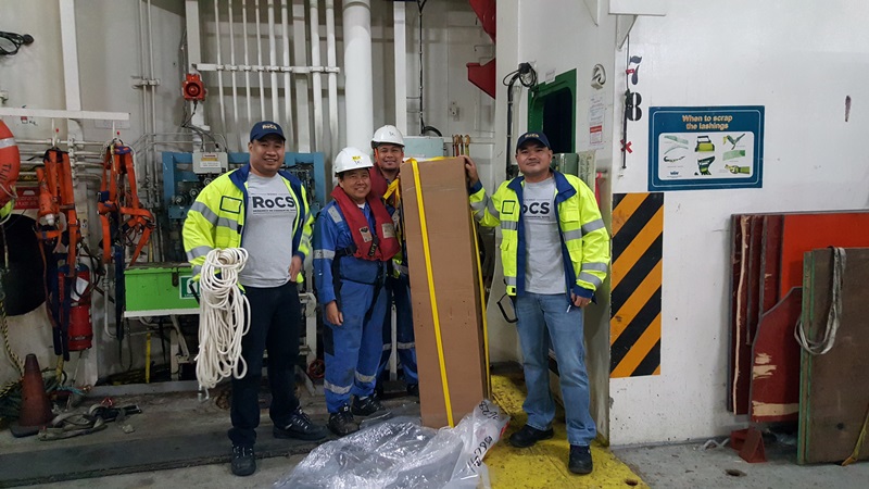
In May 2021, the crew of the Wallenius Wilhelmsen vehicle carrier M/V Tijuca deployed two WHOI Argo floats in the North Atlantic, the first collaboration under Science RoCS. Read more in WHOI’s Oceanus article on the deployment.
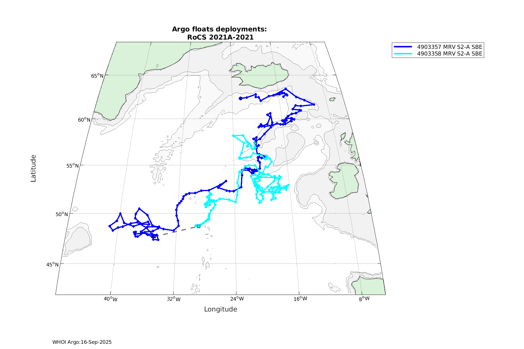
Click the map to view it at full size. Each float’s page on the WHOI Argo site has its full track, profile data, and status:
- Float WMO 4903357 (deployed May 20, 2021)
- Float WMO 4903358 (deployed May 21, 2021)
M/V Bulk Xaymaca, 2023 deployment: 5 floats
In August 2023, the crew of the M/V Bulk Xaymaca deployed five WHOI Argo floats during a southbound transit from Louisiana to Jamaica. These “fast-cycling” floats profiled every five days instead of ten to give forecasters more timely data during hurricane season, and they helped fill a gap in Argo coverage of the Yucatan Basin. Read more in NOAA’s article on the deployment.

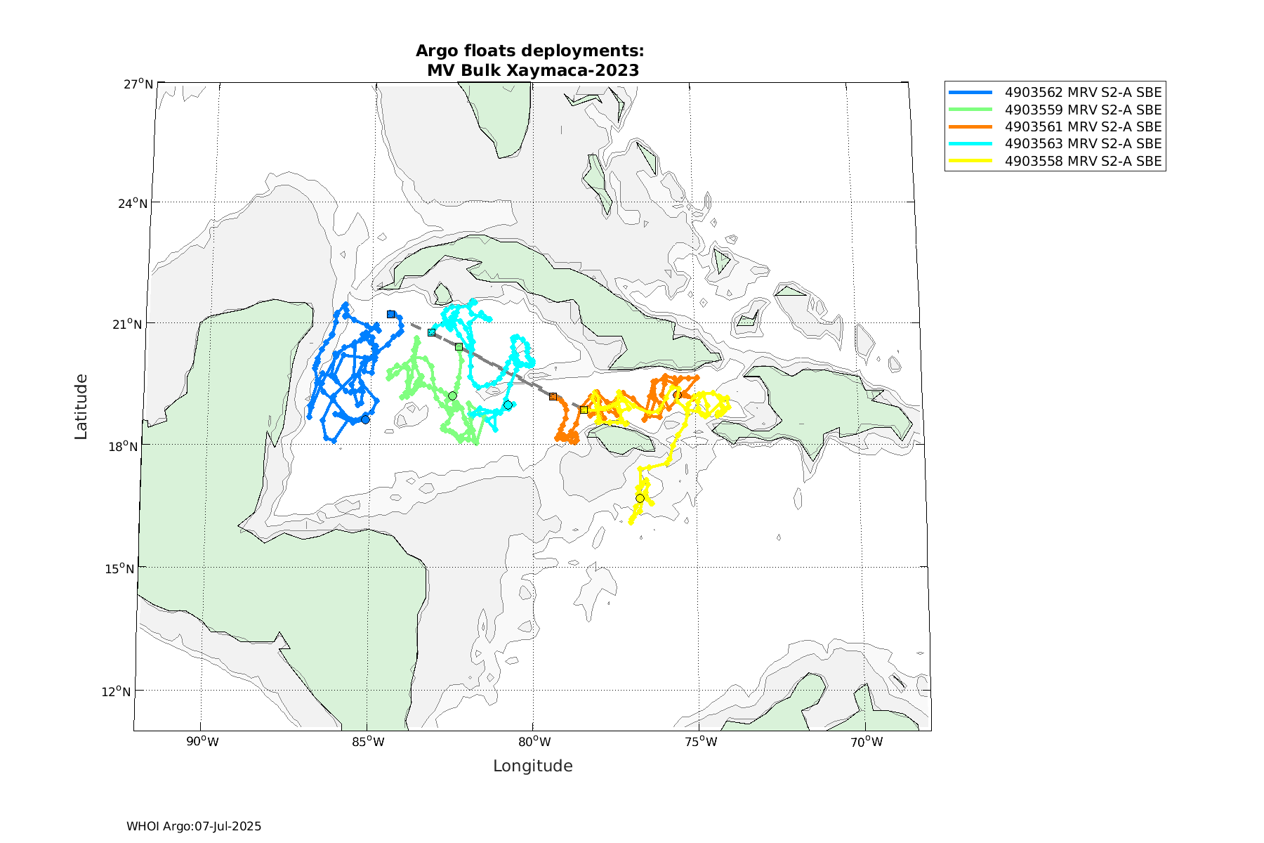
Click the map to view it at full size. Each float’s page on the WHOI Argo site has its full track, profile data, and status:
- Float WMO 4903562 (deployed August 8, 2023)
- Float WMO 4903563 (deployed August 9, 2023)
- Float WMO 4903559 (deployed August 9, 2023)
- Float WMO 4903561 (deployed August 9, 2023)
- Float WMO 4903558 (deployed August 10, 2023)
M/V Bulk Xaymaca, 2025 deployment: 5 floats
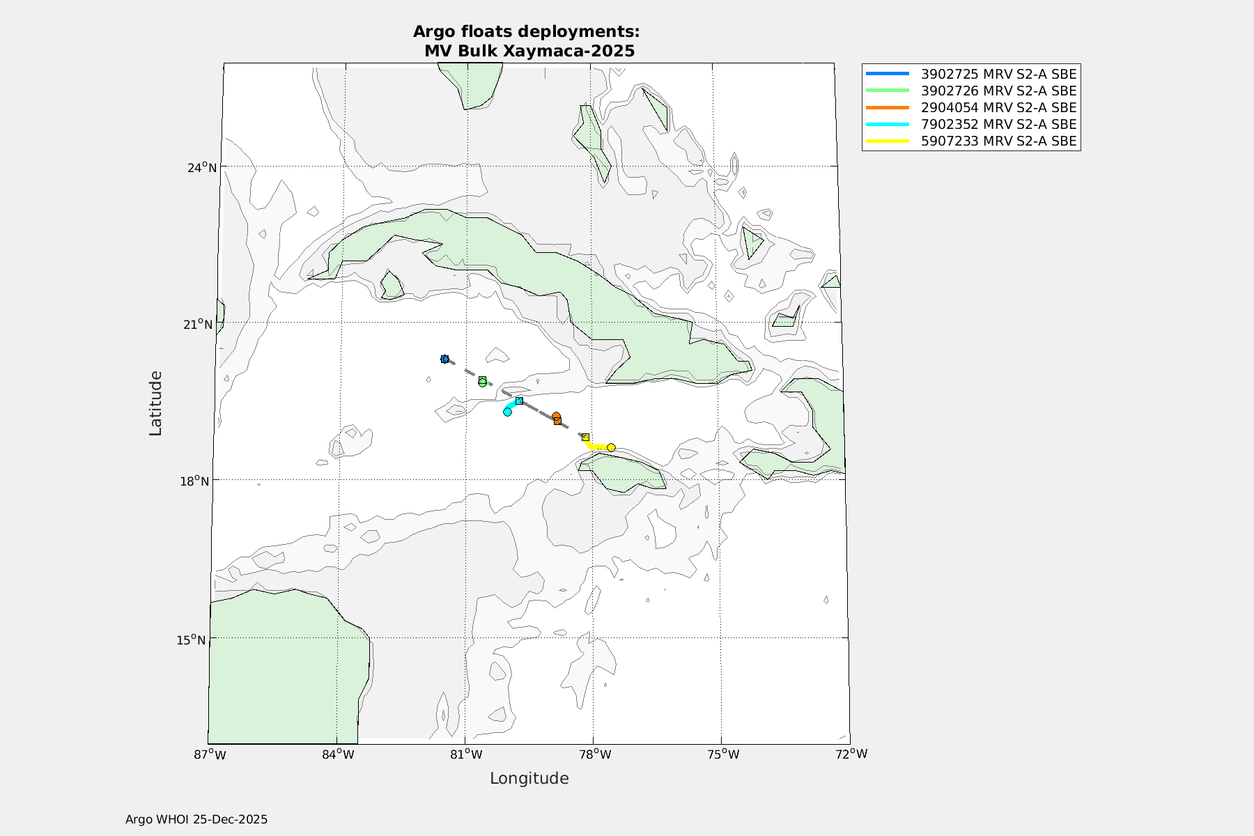
Click the map to view it at full size. Each float’s page on the WHOI Argo site has its full track, profile data, and status:
- Float WMO 3902725 (deployed December 12, 2025)
- Float WMO 3902726 (deployed December 13, 2025)
- Float WMO 2904054 (deployed December 13, 2025)
- Float WMO 7902352 (deployed December 13, 2025)
- Float WMO 5907233 (deployed December 13, 2025)